Description
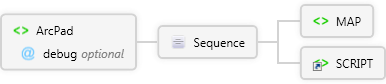
The root element for all ArcPad XML statements.
Diagram
Overview
 |
ArcPad
The root element for all ArcPad XML statements.
 |
debug optional Restriction of xs:string
Flag that determines whether ArcPad retains script code to display during run time errors. This is helpful when debugging scripts.
|
 |
Sequence
|
MAP
When parent element is ArcPad, MAP is used in ArcPad map files (*.apm) to define maps.
 |
name optional xs:string
When parent is ToolButton:
Custom tool name. Used to reference the tool in scripts.
|
|
refscale optional xs:string
Reference scale to display the TRUETYPEMARKERSYMBOL or SIMPLEMARKERSYMBOL at the specified fontsize using a relative scale such as 1:24000. TRUETYPEMARKERSYMBOLs and SIMPLEMARKERSYMBOLs are scaled relative to the refscale as the map is zoomed in or out.
|
|
Sequence
 |
BOOKMARKS
The parent element for setting bookmarks.
|
|
LAYER 1..∞
When used in a map file (*.apm), it defines the characteristics of one of the map layers.
|
brightness optional Restriction of xs:double
Brightness adjustment for the layer. Positive values increase the whiteness of the layer, negative values increase the darkness of the layer.
|
|
contrast optional Restriction of xs:double
Contrast adjustment for the layer. Positive values exaggerate color separation (as the value approaches 1, the result is either pure black (for colors below the grey threshold) or pure solid color (for colors above the threshold), for example, a dark red will become pitch black, whereas a bright red will become solid red). Negative values merge/dissolve the colors (as the value approaches -1, the result is all gray).
|
|
edit optional Restriction of xs:string
|
|
hyperlink optional Restriction of xs:string
|
|
identify optional Restriction of xs:string
|
|
maxscale optional xs:string
|
|
minscale optional xs:string
|
|
name optional xs:string
When parent is ToolButton:
Custom tool name. Used to reference the tool in scripts.
|
|
refscale optional xs:string
Reference scale to display the TRUETYPEMARKERSYMBOL or SIMPLEMARKERSYMBOL at the specified fontsize using a relative scale such as 1:24000. TRUETYPEMARKERSYMBOLs and SIMPLEMARKERSYMBOLs are scaled relative to the refscale as the map is zoomed in or out.
|
|
transparency optional xs:double
|
|
transparencycolor optional Restriction of xs:string
|
|
Sequence
|
|
name required xs:string
When parent is ToolButton:
Custom tool name. Used to reference the tool in scripts.
|
|
|
HYPERLINK
Used to specify the hyperlink properties of a layer in an ArcPad layer definition or ArcPad map file (*.apm).
|
|
METADATA
The parent element for layer meta data.
|
|
|
edge optional Restriction of xs:string
|
|
end optional Restriction of xs:string
|
|
tolerance optional xs:double
|
|
vertex optional Restriction of xs:string
|
|
visible optional Restriction of xs:string
|
|
|
SYMBOLOGY
The parent element for symbology in an ArcPad map file (*.apm) or layer definition.
|
|
|
|
MAPGRID
Used to specify map grid settings in ArcPadPrefs.apx. Also specifies map grid visibility in an ArcMap map file (*.apm).
|
visible optional Restriction of xs:string
|
|
|
NORTHARROW
Used to define display properties for the north arrow in an ArcPad map file (*.apm).
|
visible optional
Flag that determines if the north arrow is initially visible (true) or not (false).
|
|
|
PROPERTIES
Defines properties for the map in an ArcPad map file (*.apm).
|
Sequence
|
COORDSYS
Defines the projection of the data in an ArcPad map file (*.apm) or graphics layer file (*.apg).
|
|
SNAPPING
Used to specify the snapping settings for a layer in layer definitions and map files (*.apm).
|
tolerance optional xs:double
Snapping tolerance in meters. A value of 0 means that the map view's snapping tolerance is used.
|
|
|
|
|
REFPOINTS
User to specify reference points in a map for use with the offset and traverse tools.
|
Sequence
|
POINT 1..∞
When parent element is REFPOINTS, POINT defines a reference point.
|
x required xs:double
The x coordinate of the reference point in map coordinates.
|
|
y required xs:double
The y coordinate of the reference point in map coordinates.
|
|
z required xs:double
The z coordinate of the reference point in map coordinates.
|
|
name required Restriction of xs:string
|
|
|
|
|
ROTATION
Used to define rotation properties for the map in an ArcPad map file (*.apm).
|
angle optional Restriction of xs:double
Map rotation angle, expressed as an integer from 0 to 360.
|
|
autorotate optional Restriction of xs:string
Flag that determines if automatic map rotation is on (true) or off (false).
|
|
|
SCALEBAR
Used to define display properties for the scalebar in an ArcPad map file (*.apm).
|
visible optional Restriction of xs:string
|
|
|
STATUSBAR
Used to define display properties for the status bar.
|
visible optional Restriction of xs:string
|
|
|
TOOLBARS
The parent element for all ArcPad toolbars.
|
Sequence
|
TOOLBAR 1..∞
Used to define a toolbar.
|
|
|
|
TRACKLOG
Used to specify the GPS tracklog settings in ArcPadPrefs.apx. Also specifies tracklog visibility in an ArcMap map file (*.apm).
|
visible optional Restriction of xs:string
|
|
|
|
|
SCRIPT
Used in customization files (ArcPad.apx, *.apa, *.apl) to define scripts or specify an associated script file.
|
|
|
Attributes
| Name | Type | Use | Default | Fixed | Description |
|---|
| debug | Restriction of xs:string | optional | false | | Flag that determines whether ArcPad retains script code to display during run time errors. This is helpful when debugging scripts. |
Examples
Source
<xs:element name="ArcPad" xmlns:xs="http://www.w3.org/2001/XMLSchema">
<xs:annotation>
<xs:documentation>The root element for all ArcPad XML statements.</xs:documentation>
</xs:annotation>
<xs:complexType>
<xs:sequence>
<xs:element name="MAP">
<xs:annotation>
<xs:documentation>When parent element is ArcPad, MAP is used in ArcPad map files (*.apm) to define maps.</xs:documentation>
</xs:annotation>
<xs:complexType>
<xs:sequence>
<xs:element ref="BOOKMARKS" />
<xs:element name="LAYER" maxOccurs="unbounded">
<xs:annotation>
<xs:documentation>When used in a map file (*.apm), it defines the characteristics of one of the map layers.</xs:documentation>
</xs:annotation>
<xs:complexType>
<xs:sequence>
<xs:element name="DATASET">
<xs:complexType>
<xs:attribute use="required" ref="name">
<xs:annotation>
<xs:documentation>Specifies the complete pathname of a layer file (for example, c:\data\mylayer.shp) .</xs:documentation>
</xs:annotation>
</xs:attribute>
</xs:complexType>
</xs:element>
<xs:element ref="HYPERLINK">
<xs:annotation>
<xs:documentation>Used to specify the hyperlink properties of a layer in an ArcPad layer definition or ArcPad map file (*.apm).</xs:documentation>
</xs:annotation>
</xs:element>
<xs:element ref="METADATA" />
<xs:element name="SNAPPING">
<xs:complexType>
<xs:attribute default="false" name="edge">
<xs:simpleType>
<xs:restriction base="xs:string">
<xs:enumeration value="true" />
<xs:enumeration value="false" />
</xs:restriction>
</xs:simpleType>
</xs:attribute>
<xs:attribute default="false" name="end">
<xs:simpleType>
<xs:restriction base="xs:string">
<xs:enumeration value="true" />
<xs:enumeration value="false" />
</xs:restriction>
</xs:simpleType>
</xs:attribute>
<xs:attribute default="0" name="tolerance" type="xs:double" />
<xs:attribute default="false" name="vertex">
<xs:simpleType>
<xs:restriction base="xs:string">
<xs:enumeration value="true" />
<xs:enumeration value="false" />
</xs:restriction>
</xs:simpleType>
</xs:attribute>
<xs:attribute default="false" ref="visible" />
</xs:complexType>
</xs:element>
<xs:element ref="SYMBOLOGY"></xs:element>
</xs:sequence>
<xs:attribute ref="brightness" />
<xs:attribute ref="contrast" />
<xs:attribute default="false" name="edit">
<xs:simpleType>
<xs:restriction base="xs:string">
<xs:enumeration value="true" />
<xs:enumeration value="false" />
</xs:restriction>
</xs:simpleType>
</xs:attribute>
<xs:attribute default="false" name="hyperlink">
<xs:simpleType>
<xs:restriction base="xs:string">
<xs:enumeration value="true" />
<xs:enumeration value="false" />
</xs:restriction>
</xs:simpleType>
</xs:attribute>
<xs:attribute default="false" name="identify">
<xs:simpleType>
<xs:restriction base="xs:string">
<xs:enumeration value="true" />
<xs:enumeration value="false" />
</xs:restriction>
</xs:simpleType>
</xs:attribute>
<xs:attribute ref="maxscale" />
<xs:attribute ref="minscale" />
<xs:attribute ref="name">
<xs:annotation>
<xs:documentation>Name of the layer. Can be an alias.</xs:documentation>
</xs:annotation>
</xs:attribute>
<xs:attribute ref="refscale">
<xs:annotation>
<xs:documentation>Reference scale to display the symbology for the layer. The scale is specfied using a relative scale such as 1:24000. Symbols are scaled relative to the refscale as the map is zoomed in or out.</xs:documentation>
</xs:annotation>
</xs:attribute>
<xs:attribute ref="transparency">
<xs:annotation>
<xs:documentation>Transparency percentage for the layer (0 = 100 % transparent; 1 = 100 % opaque).</xs:documentation>
</xs:annotation>
</xs:attribute>
<xs:attribute ref="transparencycolor">
<xs:annotation>
<xs:documentation>Transparency color for the layer. This color will be rendered transparent in the map.</xs:documentation>
</xs:annotation>
</xs:attribute>
</xs:complexType>
</xs:element>
<xs:element name="MAPGRID">
<xs:complexType>
<xs:attribute default="false" ref="visible">
<xs:annotation>
<xs:documentation>Specifies whether the map grid is displayed.</xs:documentation>
</xs:annotation>
</xs:attribute>
</xs:complexType>
</xs:element>
<xs:element name="NORTHARROW">
<xs:annotation>
<xs:documentation>Used to define display properties for the north arrow in an ArcPad map file (*.apm).</xs:documentation>
</xs:annotation>
<xs:complexType>
<xs:attribute name="visible" default="false">
<xs:annotation>
<xs:documentation>Flag that determines if the north arrow is initially visible (true) or not (false).</xs:documentation>
</xs:annotation>
</xs:attribute>
</xs:complexType>
</xs:element>
<xs:element name="PROPERTIES">
<xs:annotation>
<xs:documentation>Defines properties for the map in an ArcPad map file (*.apm).</xs:documentation>
</xs:annotation>
<xs:complexType>
<xs:sequence>
<xs:element ref="COORDSYS">
<xs:annotation>
<xs:documentation>Defines the projection of the data in an ArcPad map file (*.apm) or graphics layer file (*.apg).</xs:documentation>
</xs:annotation>
</xs:element>
<xs:element ref="ENVELOPE">
<xs:annotation>
<xs:documentation>Defines an extent rectangle.</xs:documentation>
</xs:annotation>
</xs:element>
<xs:element name="SNAPPING">
<xs:annotation>
<xs:documentation>Used to specify the snapping settings for a layer in layer definitions and map files (*.apm).</xs:documentation>
</xs:annotation>
<xs:complexType>
<xs:attribute name="tolerance" default="0" type="xs:double">
<xs:annotation>
<xs:documentation>Snapping tolerance in meters. A value of 0 means that the map view's snapping tolerance is used.</xs:documentation>
</xs:annotation>
</xs:attribute>
</xs:complexType>
</xs:element>
</xs:sequence>
</xs:complexType>
</xs:element>
<xs:element name="REFPOINTS">
<xs:annotation>
<xs:documentation>User to specify reference points in a map for use with the offset and traverse tools.</xs:documentation>
</xs:annotation>
<xs:complexType>
<xs:sequence>
<xs:element maxOccurs="unbounded" name="POINT">
<xs:annotation>
<xs:documentation>When parent element is REFPOINTS, POINT defines a reference point.</xs:documentation>
</xs:annotation>
<xs:complexType>
<xs:attribute name="x" use="required" type="xs:double">
<xs:annotation>
<xs:documentation>The x coordinate of the reference point in map coordinates.</xs:documentation>
</xs:annotation>
</xs:attribute>
<xs:attribute name="y" use="required" type="xs:double">
<xs:annotation>
<xs:documentation>The y coordinate of the reference point in map coordinates.</xs:documentation>
</xs:annotation>
</xs:attribute>
<xs:attribute name="z" use="required" type="xs:double">
<xs:annotation>
<xs:documentation>The z coordinate of the reference point in map coordinates.</xs:documentation>
</xs:annotation>
</xs:attribute>
<xs:attribute name="name" use="required">
<xs:simpleType>
<xs:restriction base="xs:string">
<xs:enumeration value="A" />
<xs:enumeration value="B" />
</xs:restriction>
</xs:simpleType>
</xs:attribute>
</xs:complexType>
</xs:element>
</xs:sequence>
</xs:complexType>
</xs:element>
<xs:element name="ROTATION">
<xs:annotation>
<xs:documentation>Used to define rotation properties for the map in an ArcPad map file (*.apm).</xs:documentation>
</xs:annotation>
<xs:complexType>
<xs:attribute name="angle" default="0">
<xs:annotation>
<xs:documentation>Map rotation angle, expressed as an integer from 0 to 360.</xs:documentation>
</xs:annotation>
<xs:simpleType>
<xs:restriction base="xs:double">
<xs:minInclusive value="0.0" />
<xs:maxInclusive value="360.0" />
</xs:restriction>
</xs:simpleType>
</xs:attribute>
<xs:attribute name="autorotate" default="false">
<xs:annotation>
<xs:documentation>Flag that determines if automatic map rotation is on (true) or off (false).</xs:documentation>
</xs:annotation>
<xs:simpleType>
<xs:restriction base="xs:string">
<xs:enumeration value="true" />
<xs:enumeration value="false" />
</xs:restriction>
</xs:simpleType>
</xs:attribute>
</xs:complexType>
</xs:element>
<xs:element name="SCALEBAR">
<xs:annotation>
<xs:documentation>Used to define display properties for the scalebar in an ArcPad map file (*.apm).</xs:documentation>
</xs:annotation>
<xs:complexType>
<xs:attribute default="true" ref="visible">
<xs:annotation>
<xs:documentation>Flag that determines if the scalebar is initially visible (true) or not (false).</xs:documentation>
</xs:annotation>
</xs:attribute>
</xs:complexType>
</xs:element>
<xs:element name="STATUSBAR">
<xs:annotation>
<xs:documentation>Used to define display properties for the status bar.</xs:documentation>
</xs:annotation>
<xs:complexType>
<xs:attribute default="true" ref="visible">
<xs:annotation>
<xs:documentation>Flag that determines if the status bar is initially visible (true) or not (false).</xs:documentation>
</xs:annotation>
</xs:attribute>
</xs:complexType>
</xs:element>
<xs:element name="TOOLBARS">
<xs:complexType>
<xs:sequence>
<xs:element ref="TOOLBAR" maxOccurs="unbounded"></xs:element>
</xs:sequence>
</xs:complexType>
</xs:element>
<xs:element name="TRACKLOG">
<xs:annotation>
<xs:documentation>Used to specify the GPS tracklog settings in ArcPadPrefs.apx. Also specifies tracklog visibility in an ArcMap map file (*.apm).</xs:documentation>
</xs:annotation>
<xs:complexType>
<xs:attribute default="false" ref="visible">
<xs:annotation>
<xs:documentation>Specifies whether the tracklog is displayed.</xs:documentation>
</xs:annotation>
</xs:attribute>
</xs:complexType>
</xs:element>
</xs:sequence>
<xs:attribute ref="name" />
<xs:attribute ref="refscale" />
</xs:complexType>
</xs:element>
<xs:element ref="SCRIPT" />
</xs:sequence>
<xs:attribute default="false" name="debug">
<xs:simpleType>
<xs:restriction base="xs:string">
<xs:enumeration value="true" />
<xs:enumeration value="false" />
</xs:restriction>
</xs:simpleType>
</xs:attribute>
</xs:complexType>
</xs:element> |
See Also